Map Accuracy
Maps and Tracks: Accuracy, Precision, and your Phone GPS (Part 1)
We are frequently asked about our maps, their accuracy, and the accuracy of tracks, routes, and lines. This is part one of a two part series to help explain some of the nuance in mapping. Inherently this can be a bit of a dense topic so we’ve broken it down with some clear sub topics that may be of interest.
Is CalTopo’s map wrong? Of course it is! All maps are inherently wrong to some degree. There are many ways to evaluate how “good” a map is, and all of those evaluations are subjective based on the needs of the map user.
Maps are by nature inaccurate to some degree. Maps represent the real world at a given time and place. The real world can change over time with dramatic events such as landslides, or something as little as a trail re-route. Each place is interpreted by both the map maker and the map user. The map maker chooses what information to include in the map, where to source that data and how to display the results. The map user interprets the map based on what they are trying to use it to accomplish. A hiker may use the same map very differently than a paraglider.
We build our maps from other sources. CalTopo does not go out in the field and measure things or inquire about the name of a feature. Our goal is to provide you with lots of options, and build a program that allows you to add your own information to a map, or use the existing base maps to navigate or discover things.
GPS on your phone is not as good as you might imagine it to be. It’s actually really good when you consider all the technology in place to allow your phone to find your location anywhere on the earth in a matter of moments. However, if you are looking for really precise information about how far you just hiked down to the foot, or even to the quarter mile, that’s just not a thing given the conditions where most people hike.
Below we discuss the details of all these principles extensively. If your interest in the specifics of map making and GPS accuracy is piqued, read on.
What Makes a Map?
To begin to address the question of how good is a map, we need to consider some basic principles of cartography, the science of map making, and Geographic Information Systems (GIS). Here is some background information to get you started:
-
Principles of Measurement: In regards to measurements, what is accuracy, and what is precision? While related and sometimes dependent on each other, these two properties of a set of measurements are not the same thing. You can think of an accurate measurement as one that is very close to the TRUE value of the thing being measured. For example, a GPS signal from a satellite may be said to be within a 4m accuracy 95% of the time. A precise measurement is one that is consistent with other measurements of the same phenomenon. If the values given consistently fall close to each other, then the set of measurements is precise. If your GPS unit consistently puts you 4-5m west of the summit of a peak while you are standing on the peak, it may have a very precise measurement, though it has a systematic accuracy error.
-
The Shape of the Earth: The earth is neither round, nor perfect elliptical. Presenting a round surface via a flat surface is mathematically impossible, and doing so for something that isn’t even perfectly round is even more difficult. The Map is not the Earth: Just as the architectural drawings are not the building, a map of a forest is neither the forest nor the trees. The goal of a map is to represent something that we otherwise can’t fully see or understand without using a reference tool. The map is that tool. The map intentionally distorts reality to make it easier to understand, reference, and use.
-
Map Scale: Maps are produced at scale to represent locations on the surface of the earth. Scale is directly proportional to the accuracy of any point on that map. Small scale maps show relationships between distant and large objects but would have a hard time designating small, detailed objects. Conversely, a large scale map shows a smaller geographical area and is more accurate in regards to smaller objects. Large scale maps are represented by smaller numbers on the right side of the ratio expressing the size (IE 1:250,000 is a small scale covering a wide area, while 1:12,500 is a large scale covering a small area.)
-
Map Purpose: The purpose or intended use of the map matters with regards to the needed level of accuracy. There is little practicality in making a map intended for hiking to be accurate down to the centimeter. While we might want to know the exact height of a mountain down to the centimeter in order to find out which is the tallest, the length of a trail measured to this detail would be impractical and not very useful. If a hiker walks the inside of every curve and another hiker hikes the outside of every curve, they would walk different distances, but not in a way that would appreciably matter.
Every map aims to show something different to the user, and much of this depends on the purpose the map maker had in mind for the map. Sometimes they may be more aesthetic than practical, and other times so exact about one thing that they miss an opportunity to share other important information. At CalTopo, we offer a collection of maps that we refer to as base layers. Each map we offer in the base layer and overlay lists has been carefully selected to provide data that:
- Is meaningfully different from other layers already provided,
- Is useful to users in the world of outdoor pursuits, disaster response and search and rescue, and general interest, and
- Provides accurate and quality information.
Basic Map Types
Maps generally fall into one of two categories: reference maps and thematic maps. While thematic maps often look to answer a single question or concept, reference maps aim to provide an array of information that allows the user to identify objects, relative locations, distances, areas, finding a route, or understanding topography and vegetations – all in one map. The base layers you find in CalTopo are generally reference maps, as they contain a variety of information and topography. Overlays are more similar to thematic maps. For example, the max wind speed overlay shows no information other than a plot of the predicted wind speed. It doesn’t reference natural features, roads, or vegetation. It covers one topic only, though that topic is tied to locations on the surface of the earth.
Reference maps are often used as base maps for adding additional geographically referenced features on top of those maps. Reference maps are built using a variety of tools, and many of those tools have become more and more powerful over recent years. Satellite and aerial imagery play an important role in building maps, and increasingly tools such as light detection and ranging (LIDAR) bring high-resolution elevation data into the mix. This data allows more accurate slope angle analysis, elevation calculations along a line, and small-scale changes in elevation.
Within CalTopo, some layers are dynamic and incorporate new data as it becomes available (think living, breathing layers) whereas other layers, such as the Scanned 7.5′ maps, are digital images of maps designed at a particular point in time, many before Geographic Information Systems (GIS) even existed.
Raster vs Vector
Digital maps come in two forms: raster and vector. Raster data are grids with values set per grid cell. Elevation data is typically stored and displayed in a raster format. It is continuously variable, starting from some set value such as mean sea level, with each cell falling a specific distance above or below that established zero level. However, raster data is not always visually pleasing and can be more difficult to interpret. For example, the Fire Activity overlay in CalTopo is raster data. Each star and circle combination represents one cell of data. Each point represents a positive indication of a hotspot within the raster cell, and the circle represents the error radius of that data point. The larger circles mean that the angle of view from the satellite is more oblique than from straight above, and so the error radius for the where the hotspot is located is larger.
Vector data is composed of points, lines, and polygons and can grow and shrink with scale. The main advantage of vector data is that visually it is more pleasing and natural to understand. It works well for representing objects that have discrete boundaries, such as roads or coastlines. Processing vector data can be challenging and memory intensive.
Maps generally fall into two categories, reference and thematic, and are made of two types of data, raster and vector. These components come together to build the map, along with the goals of the map maker and target users, and the cost of obtaining and assembling data. Each map therefore has a practical limit to its level of accuracy. The next section considers map accuracy more closely.
Building Accurate Maps
Let’s play with a thought experiment. You are building a new map from scratch and you go out and climb two peaks and measure the distance between the summits of those two peaks. How accurate is the distance you measure? More importantly, how accurate does it need to be? Say each peak has a pile of rocks on top, and during winter snows, the top most rock shifts a few centimeters to settle a little more into the rocks around it. Is your measurement now wrong? How much does it matter, and to whom? Would those few centimeters difference make it significantly easier to get to the top of the peak? Probably not.
Now consider that to build your map, you need to measure 5 peaks, or 10, or 30, and their relationship to all the other peaks around each. The practicality of measuring each of these down to centimeters is pretty low considering that the scale of your map is going to be something like 1:12500 and there is no way to represent those centimeters of difference on your map. Adding labels to your map to show these very exact differences would obliterate the ability to see anything else. It would no longer be a reference map, but a thematic map conveying only one small subset of information, and not very useful for navigating.
In fact, for the purposes of navigating across terrain, even being a meter or so off in any direction really doesn’t matter that much. In fact, the USGS only guarantees 90% of well-defined points to be accurate to within .02 inches of their actual positions on maps with a scale smaller than 1:20,000. On a map with a scale of 1:250,000, this translates to an accepted error of over 400 ft horizontally.
Maps are inherently inaccurate. They are always a representation of the real world, and not the real world itself. This is the philosophy of mapping at its core. Every map maker must decide what information to include on the map, based on what the purpose of that map is and who will be using it. No map can include everything that any person may want to understand.
One way to improve map accuracy is to gather data from many, many sources. An open-sourced mapping project called OpenStreetMap works with contributors worldwide to gather and maintain geographic information for building maps. Anyone can create an account and start contributing to the project. The more users that add GPS traces or that draw over satellite imagery for a particular location, the more accurate that feature becomes over time. In areas with a lot of users and traffic, OSM data can be highly accurate. CalTopo draws from this data for a significant portion of the map products that it builds. We offer the MapBuilder Features overlay to add information about the route designations included on the map.
CalTopo does not go out into the real world and measure things on the ground and build maps from that data. We use a variety of well-established data sets and sources to assemble the layers you see as options in CalTopo. Some of these are fully produced layers and we pull the tiles in to display via our system. Others, like MapBuilder Topo and Custom MapBuilder layers, are groups of data such as land cover, slope angle, elevation, and roads and trails that can be assembled to create a map.
Using Layers to Better Understand Terrain
One person’s idea of a trail may not match another’s idea of the same trail. Let’s look at an example of how OSM data and USFS data show different details about some trails. Consider a “social* trail” or a “climbers trail”. These may show up on maps as trails, but on the ground they are faint, difficult to follow, unmaintained, overgrown, or involve scrambling over small cliffs. They may still be important to have on the map: the climber may really need a reference of the safest route to descend from a climb. The hiker may find that same trail to be extremely dangerous. Thus, the user must consult various maps and any associated reference materials to understand what the intended use of the map is and what routes are represented there.
Sometimes social trails are not approved by the land owner or manager. Just because someone mapped it doesn’t mean that it’s a legal trail. It’s always your responsibility to understand the land use rules in a given area. A map may have the trail on it because the map maker views the map as a documentation of what exists on the ground, rather than what the approved travel routes are.
One quick and helpful way to find out how useful a particular map base is to your goal or project is to compare it to other maps of the same location. This is the principle behind offering many Base Layers in CalTopo. Each of our base layers is carefully selected to complement and contrast other base layers, in order to provide a breadth of different information.
The two images below represent the same location. The first is from the MabBuilder Topo base layer, and the second is the FS 2016 base layer. The prominent red trail across the center of the first image is missing in the second layer. If you look closely, you can see the black portion of both trails in each image. Why is the trail missing on the USFS map – an official map for the Forest Service?
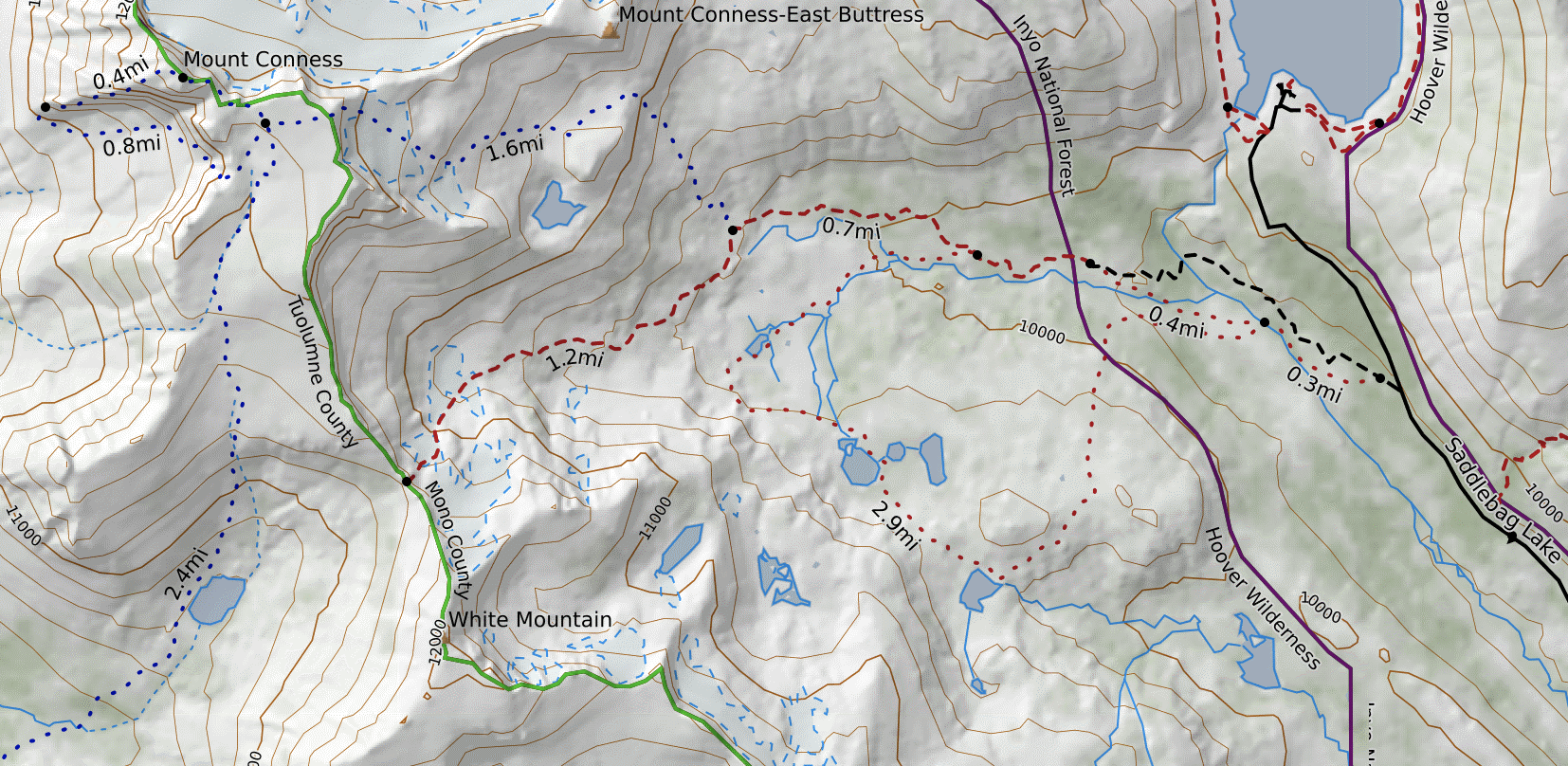
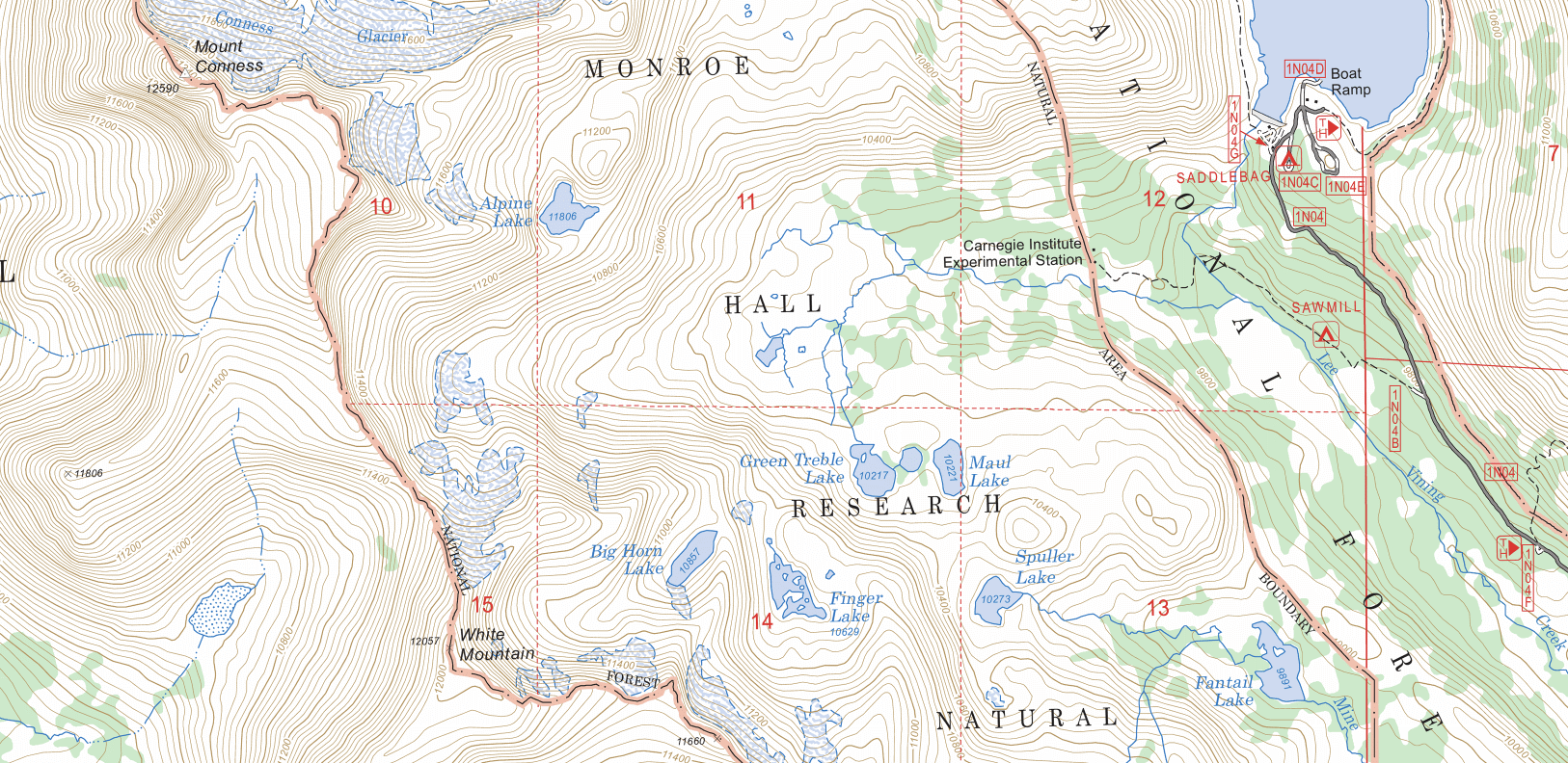
Turning on the public lands overlay, I can confirm that the trail is on USFS lands, so it’s not an issue of the USFS maps sometimes covering areas that aren’t USFS land. Turning on MapBuilder Overlay, the trail returns to the map. Thus we can assume that the trail is in OSM data but not in USFS data.
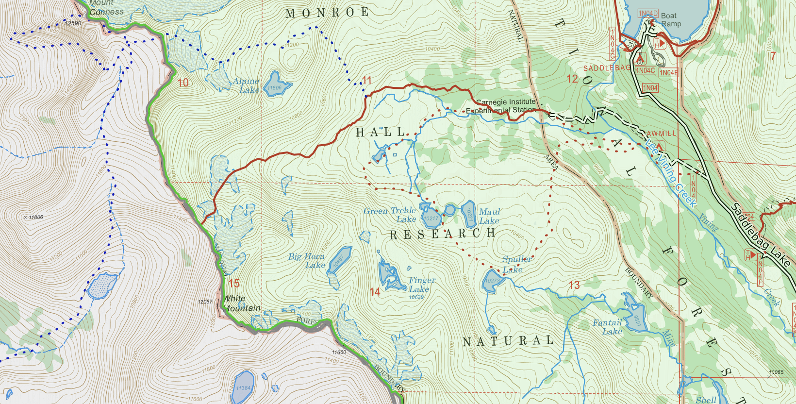
A probable explanation for this difference between the base layers is that the trail we see in MapBuilder is not an official and maintained trail. It may have been a trail in the past, and now is used by backcountry explorers and people climbing peaks in the area. A hiker that isn’t used to following faint and broken trails may have difficulty on this route, while other backcountry travelers may find this trail to be more fun than other, clearly marked ones. At other times, a trail that appears on one map but not another could be illegal, closed, rerouted, or rehabilitated. So, this is a great example of how using a variety of base layers and map sources can help you plan. (You can also refer to the MapBuilder Features overlay to learn more about a specific path and determine the quality of trail it is categorized as.)
Sources:
https://gisgeography.com/spatial-data-types-vector-raster/
https://www.e-education.psu.edu/natureofgeoinfo/c1_p16.html
https://www.pcmag.com/encyclopedia/term/map-accuracy
https://www.thoughtco.com/what-do-maps-really-do-4088786