Course: CalTopo (SARTopo) for Incident Response
introduction
Please read everything.
CalTopo is used by first responders worldwide to manage incidents of all sizes, whether that be backcountry search and rescue, natural disaster response and recovery, or many other uses.
Though you may know the program by the name SARTopo, that name is being phased out. Currently you can use either sartopo.com or caltopo.com to access the same maps and data.
Map mode will determine whether SAR-type objects, such as assignments, are available in the +ADD object menu.
Class Purpose
The purpose of this course is to demonstrate and practice how to effectively integrate CalTopo into all stages of your incident response from start to finish.
While this course will focus on multi-operational-period searches as an example, the same CalTopo tools and skills can be applied to other types of incidents as well.
Certificate Opportunity
We have partnered with NASAR to provide a free certificate of completion for this course. To obtain a certificate you will:
- Register for the course at NASAR's online class platform
- Read all course content.
- Create your own CalTopo map by completing ALL exercises in the course to demonstrate your understanding of the material.
- Answer quiz questions on the NASAR Thinkific course site.
- Submit your own work for review via the Thinkific platform.
A representative from CalTopo will review your final map submission and reply. You may be asked to make edits and re-submit your map.
Course Topics
- Initial Response: evaluate terrain and create a hasty map.
- Risk Management: research current and forecasted conditions, plan ingress and egress routes, and evaluate potential landing zones
- Segmenting and Assignments: set up a map that has effective search zones for the second operational period and beyond.
- Deployment and Incident Action Plan: send a team into the field using the mobile app and map packets and forms.
- Tracks and Data Management: clean up search tracks and handle the incoming data.
- Scale Up: be prepared to handle larger incidents incorporating multiple agencies.
Prerequisites
This is not a mission management class and we do not claim to teach it here. To succeed in this course, you already should have some general understanding of the topic.
You should have a baseline understanding of how to use CalTopo. If not, we recommend first reviewing our Getting Started Guide and completing the shorter course Critical Skills for Mobile Use.
The lessons here assume that you have a CalTopo Teams group subscription, rather than an individual subscription.
Anyone using an individual account will need to reference the user guide to make adjustments for how to share maps effectively, among other things. You may also email us at help@caltopo.com and request a trial code for a temporary Pro account before taking the course.
Scenarios
This course utilizes three sample scenarios in three different environments (suburban, rural and mountainous). We interweave these examples throughout each chapter to demonstrate how to use the tools and features described.
These scenarios should provide realistic examples of how you would use CalTopo at different stages in the incident response process.
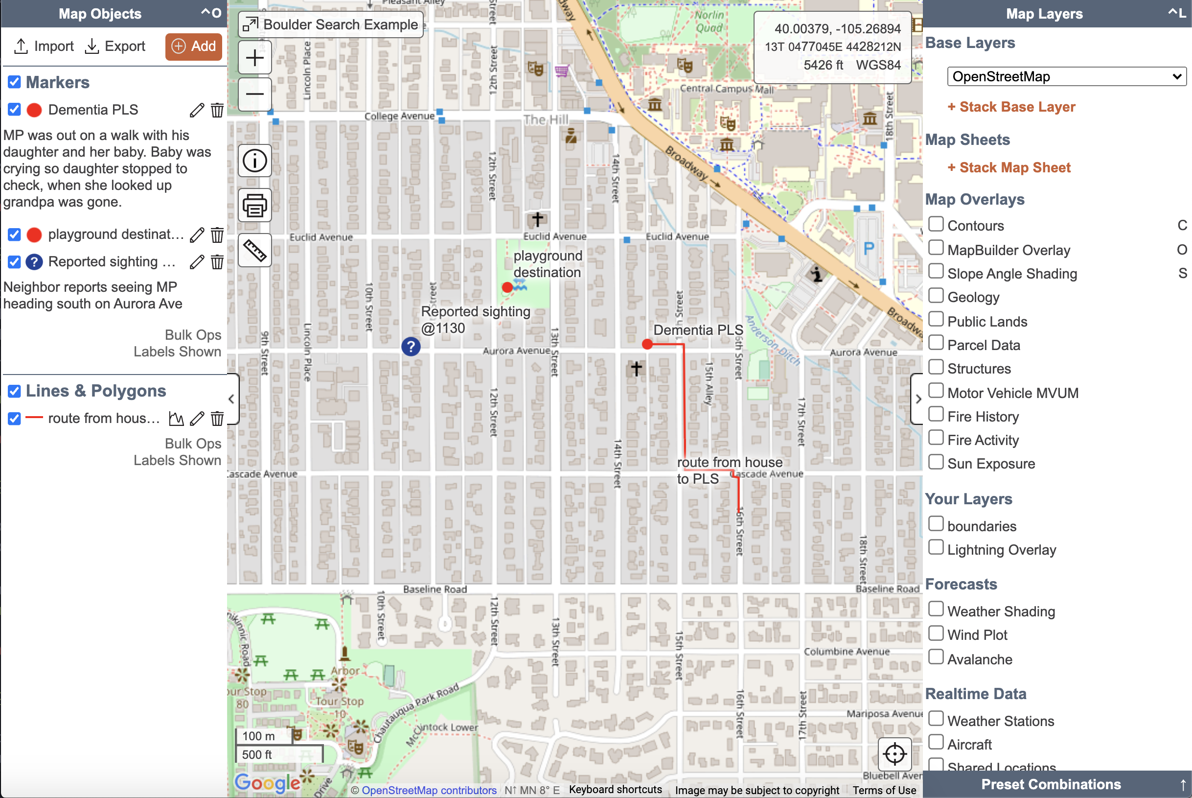
Scenario #1: Missing Dementia Patient in a Suburban Area
View this Map: Boulder Search Example
A missing 73 year old female has dementia and a history of getting disoriented and lost. She disappeared while on a walk with her family in their suburban neighborhood in Boulder, CO when the family members became distracted. Below is the search map for this scenario with the initial information received.
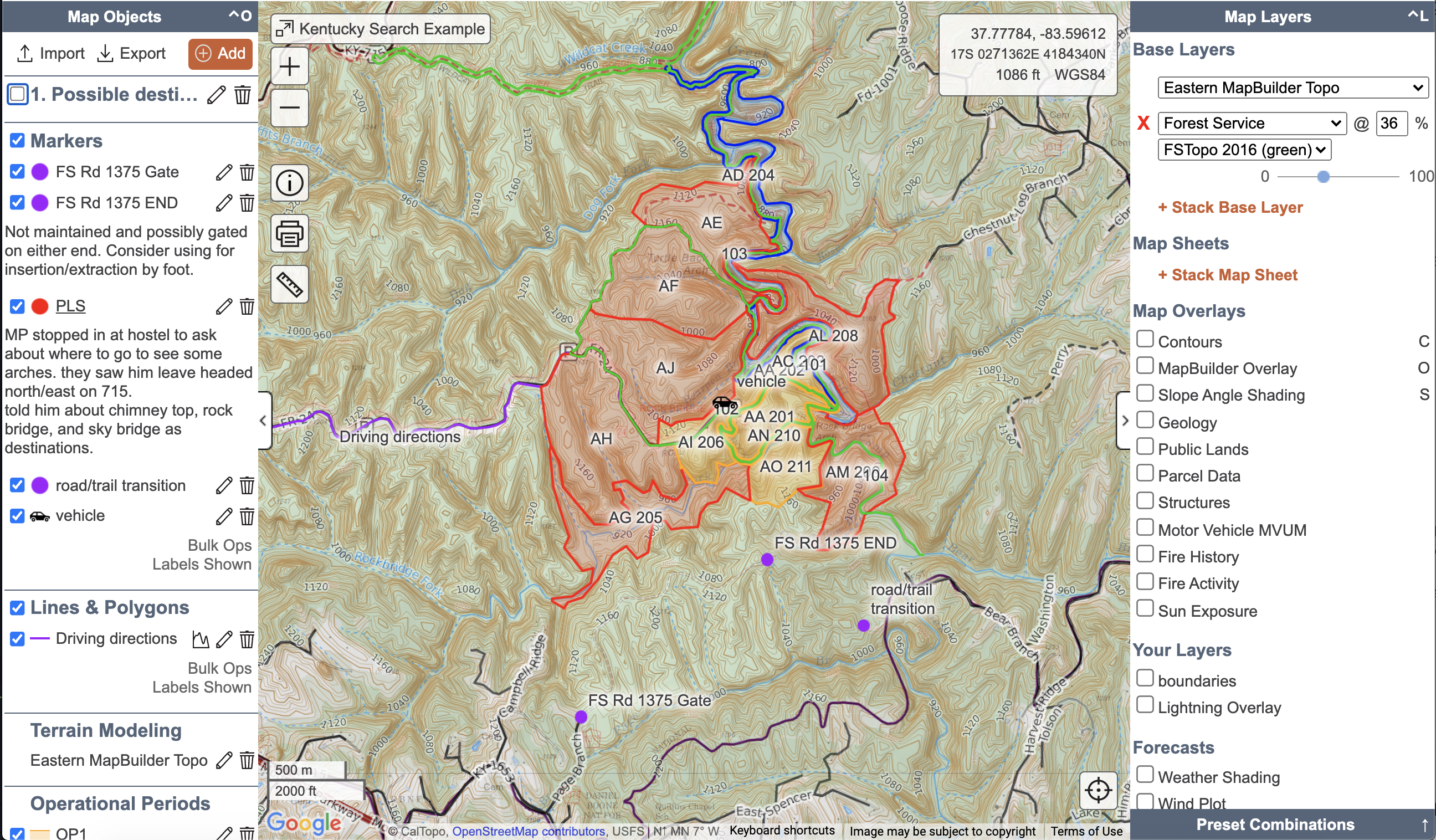
Scenario #2: Missing Hiker in a Rural Area
View this map: Kentucky Search Example
In our next scenario, a 45-year old male is reported missing after he failed to check out of a hostel in Pine Ridge, KY. His car was later found by a sheriff’s deputy at the Rock Bridge Trailhead and he is believed to have been out hiking in the area.
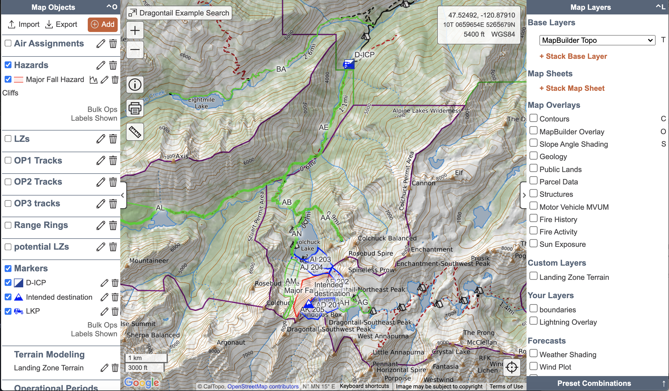
Scenario #3: Missing Mountaineer in the Cascades
View this map: Dragontail Example Search
In this scenario, a 30-year-old male is reported missing in the Alpine Lakes Wilderness outside Leavenworth, WA. His goal was to climb Dragontail Peak from the Mountaineer Creek Trailhead in a single day. His wife reported him missing after he failed to call or return home the previous night.
Exercises
Exercises follow a mock incident. You will apply the knowledge from each section to a map you create to support the mock incident.
An example of an exercise as it appears in the course is shown below.
Exercise #X
Instructions for the exercise will be here. They will tell you what to add to your map, which should be based on the skills you were just learning about for that section.
The exercises will lead you through creating a mission map for a missing person scenario. Details of the scenario will be included in the exercise instructions.
Grading Criteria:
- Grading Criteria sections will list each item that must be done or included on your map before submission.
- Map submissions that do not include all grading criteria may be rejected from receiving a certificate.
Reference Links:
Exercises are designed to be completed in the order that they appear in the course. Each exercise builds off the previous exercises and should be completed in the same CalTopo map that you create in Exercise #1.
By the end of the course, you should have one CalTopo exercise map in which you’ve completed all the exercises in order. It will include data from the hasty search phase all the way through the final operational period.
Now, let's get started with the Initial Response and Hasty Search.